")
")
")
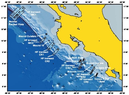
 Asset Publisher Asset Publisher « Back M54-3a, Chronological Work Report, September 10 - September 28, 2002During the second leg we established 6 working areas where extensive sampling and surveys were done; in addition 3 other areas were investigated with only a few stations. The main areas from north to south are: (1) Horst-and-Graben, (2) Mound Culebra, (3) Mound#10, (4) Jaco Scarp, (5) Mound#11 and (6) Mound#12; the minor areas were BGR-slump, mud pie and Cocos Ridge. The nomenclature is taken from previous legs and is being used throughout the report; the areas and stations are shown in Fig. 1.
Figure 1 Stations during cruise M54-2 and 3.
Week 1 The events during the week from 09.09.2002-16.09.2002 were as follows: On September 9th we held a very successful reception on board the FS METEOR for guests invited by the local embassy of the Federal Republic of Germany. During the morning there were tours for school classes, as well as interviews with press agents and national television stations, and in the early afternoon the participation exceeded all expectations with more than 100 guests from local diplomatic, administrative and academic institutions. The crew’s outstanding preparations included not only the elegant buffet, but also help in leading tours of the ship for different groups of guests. Highlights of the occasion were the presentation of our new land-and-offshore 3-D relief map of Costa Rica to various official representatives of the country by the Chief Scientist, as well as the numerous personal contacts with colleagues and employees of relevant scientific institutions. The map was presented in the name of the SFB 574 and Christian-Albrecht-University. During the whole time of the reception, preparations continued with setting up laboratories and equipment so that the FS METEOR could depart Caldera harbour September 10th, 10:30 local time, with 24 scientific personnel on board, setting course for the furthest northwest field of research, the ‘Horst-und Graben’ structure offshore Nicaragua. There, using the OFOS, three of the steep terraces next to the deep-sea trench were investigated at 4020-4350m; 4510-4750m; 4650-4950m. These almost vertically walled terraces showed spectacular exposures of basaltic crust layered over with sediment. It was surprising that the sequence of basalts was thicker than the sediments lying on top. At the bottom of the steep terraces lay strewn widespread heaps of basalt blocks and boulders. The deepest of the steep terraces seemed to be the most eroded and fractured, the middle one showed the best developed contact between sediment and basalt, and the shallowest terrace was similar to the middle terrace but heavily populated by sessile organisms. The contact on the middle terrace showed white precipitates and crusts which were initially interpreted as products deposited from ascending fluids along the contact plane. The TV-grab sampler, however, brought back only pure nanochalk from that contact depth. The precipitates could not be identified. The clear finding is that there is no indication of active fluid emission –either at the deeper end of the seaward-leaning terraces, nor at the contact between sediment and basalt. The second half of the first week we spent investigating the northern section off Costa Rica, where the EPR-generated crust is subducted. Here two different sites were investigated in more detail. At Mt. Culebra we followed a WNW-trending fault, documented by intensive carbonate formation and populated by colonies of mussels and pogonophorans. A gravity core over an acoustic anomaly ("white spots" on the Parasound recording) showed uniform hemi-pelagic sediment. At a depth of 600 cm, however, clear chloride, CH4- and H2S-anomalies were measured in the pore water, which are an indication of ascending fluids. Several TV-guided MUC operations produced no recovery, either because carbonates prevented penetration or the sediment recovered no indication of fluid movement. These operations became very time-consuming because of the poor quality of the video transmission during the TV-MUCs. It was also difficult to clearly evaluate the nature of the sea floor in vent areas. Several CTD profiles with near-bottom CH4-maxima completed the range of samples around Mt.Culebra. The bottom-water sampler was also deployed very successfully, showing a direct connection between methane contents of near bottom layers and those higher up in the water column. One of the VESP-Landers was deployed during the night of 5/6 September to complete the operations at Mt.Culebra. The VESP-Lander was to record expulsion activity until the end of the expedition. The second area investigated in detail, alternately with Mt. Culebra, was Mound # 10 situated about 17 sea miles SE, at a depth of 2300 m. From earlier investigations, it was known that there was less contiguous carbonate surface, so the TV-MUC sampling was accomplished more successfully than at Mt. Culebra. This was confirmed by TV-MUC which produced a pronounced enrichment of CH4 and H2S and a decrease in chloride at a core depth of only 4 cm. A gravity core about 400 cm from the top of M#10 showed the highest methane content so far, as well as a strong change in the methane gradient and an increase in sulfide at a depth of about 250 cm; thus ascending fluids can be assumed. The first deployment of a Benthic Chamber Lander (BC-L) was at Mound #10. Here it was not possible to penetrate the sediment sufficiently, however after 30 hours one of the 4 samplers contained a complete time-series of samples . Two others did not function properly and a third was damaged during recovery. In the area around Mound #10 there had as yet been no CTD-survey of methane distribution in the water column. Two depth profiles, one above the top, the other at the western edge, resulted in identical patterns of methane distribution identical in the near-bottom water. This distribution confirmed all previous observations on CH4-maxima directly at the bottom and a continual decrease upwards. This is to be interpreted as a fluid source and not as bubble transport of the methane. After completing the station work, we transited to the southern area of investigation around Mounds #11 and #12. From here, all other areas could be reached within a few hours, so several investigative goals were worked on alternately. The sea was exceedingly calm so far; the temperature of 28°C and the high air humidity was not everyone´s cup of tea, but this did not dampen the good spirits. Week 2 The events during the week from 17.09.2002-23.09.2002 were as follows: We spent time investigating the southern section offshore Costa Rica where the Galapagos-generated crust is subducted. We worked alternately in two areas 32 nm from each other: the Jaco Scarp and the Mounds #11 and #12. The scarps and mounds emit various types of fluids from different depths; the mechanism responsible for the fluid-movements seems to be respectively different as well. Therefore, the comparison of mounds and scarps is of high scientific priority. Mounds #11 and #12 are gentle morphological elevations at 1000 m depth offshore Quepos, with a relief of maximum 30 m at the middle slope. Earlier OFOS observations had documented active fluid venting based on carbonate formations and vent communities. During leg M54/2 the mounds were identified as mud volcanoes with a more or less contiguous carbonate platform on top. Gas hydrates were also found about 200 cmbsf on the southern flank of Mound #11, a mound characterized by high heat flow. At the beginning of the week several gravity cores were taken at the position of the gas hydrates and in the center of the mounds. All of them terminated at about 200 cmbsf because penetration failed when they encountered compact layers of gas hydrate. Regrettably, we were not able to sample any of the gas hydrate. All cores contained either layers of volcanic ash of different thickness (1-20 cm) cemented by carbonate, or layers of different types of carbonate concretions. TV-guided multi-corer deployments at those stations where the gravity cores failed or at positions with bacterial mats allowed an exact delineation of the pore water-concentration gradients near the surface. In general, the chloride contents decreased significantly to as low as 250 mol/L. Methane, hydrogen sulfide, and alkalinity increased significantly caused by ascending low-salinity fluids. Freshening may, however, also be caused by dissociation of gas hydrate. Both types of chloride decrease were measured. The deployment of the BC-L was a remarkable success. Near bacterial mats at Mound #11, it recorded a 30-hour continuous decrease of oxygen and nitrate to values less than half those of the bottom water, with a simultaneous increase in methane. The sediment enclosed in the chamber was sampled for high-resolution pore-water chemistry. A detailed OFOS-survey of Mound #12 showed that active venting is presently taking place on the southwestern flank. Bacterial mats and carbonate-edifices (irregular chimney formations found with venting communities) are present here. Continuously younger carbonate formations extend from the top down the southwestern flank. Platy crusts of interrelated carbonates build up the top of Mound #12. Fractures between the carbonate plates are extraordinarily densely occupied by Bathymodiolus colonies (vent shell) whose margins are discolored by bacterial mats. Along the downward edge of the slope fewer carbonates and more vent-organisms were observed; i.e. fragmented pieces of carbonates with dense fields of living mussels grading into fields of empty shell debris, followed by single clams and bacterial mats at the western margin of the active field. The highest solute concentrations of pore water were obtained from sediments sampled by TV-guided multi corer at bacterial mat sites. Approximately 20 mMol/L hydrogen sulphide were measured at a depth of only 20 cmbsf; alkalinity, chloride and methane were likewise extremely high. The BC-Lander and the VESP-Lander were positioned on Mound #12 and we continued taking water column samples by using CTDs and the in situ pump. Particulate matter was collected with the in situ pump to isolate biomarkers. These are expected to be characteristic of vent-activities. Between 10-15 cm off the seafloor at Mound#11 an exceedingly high methane content of 120 mMol/L was measured as well as strong gradients. In this way we succeeded in documenting the continuous transition of the methane concentrations between the measurements of the CTD-rosette and the bottom water sampler. Jaco Scarp represents the best-defined and, with its bathymetry, the most outstanding feature generated by seamount subduction. .Along this feature a volcanic seamount originally situated on top the Galapagos-generated crust plowed into the slope sediments. Such features open up routes for fluid- and gas-emission and by this means contribute to the dewatering of subduction zones. Jaco Scarp extends from its upper edge at a water depth of 1000m down to 2300m. Inside the semi-circular scarp face there is an apron of debris and boulders which, after the passage of the seamount, were loosened from the sides and the head wall. Above 1900m the sediments of the slope are exposed and free of debris, forming several abrupt steps up to almost 1000m of water depth. From earlier investigations, we know that here fluid venting is active as shown by methane anomalies in the water column and by the presence of vent communities. Based on these results observed between 1700-1900 m, at the lower end of the exposed layers , the entire width of the caldera was searched and sampled for vent phenomena. The results indicate that venting is restricted to the center of the exposed head wall with the most active spot between 1760-1840 m. Here fluids exit horizontally from the exposed indurated layers of mud stones and support a shrubbery of pogonophoran colonies which stick out of the vertical wall. At several spots we observed caves where these colonies prosper even more than at the walls. Vent shells (Calyptogena) are found in the colonies as well. They are restricted to debris aprons and narrow ledges at the base of the vertical wall, primarily at a depth of about 1800 m but also around 1700m. Only at these ledges did we succeed in sampling by using the TV-grab. The material consisted mainly of mud-stone pebbles with a bit of sediment mixed in. In spite of their high permeability, and therefore the possibility of considerable admixing of bottom water, chloride values of 440 mM/L —considerably lower than seawater-- were measured in the pore water of these sediments. The TV-MUC could not be used here because of the rubble, however two locations were found where the Lander could be deployed. This week once again the sea was calm, with air temperatures decreasing slightly compared to the week before. Also strong and frequent showers combined with thunderstorms, mostly at night, made temperatures more bearable. Week 3 The events during the week from 23.09.2002-29.09.2002 were are follows: First, following a Parasound survey, we sampled a gravity core from a small slide area on the upper slope (BGR-slump). A reflection seismic profile of the slide area showed a chaotic development of the BSR, which suggested possible methane degassing. The 320 cm core showed 50 cm of recent sediment deposited above an erosive discontinuity of older and much more consolidated sediments below. This superposition enables us to obtain an exact dating of the slide phenomenon. At the same time, the physical characteristics of the exposed deeper sediment might allow a reconstruction of the circumstances of the slide. Following this the older VESP-sampler modified to carry a timed sequence of 5 water samplers on a cable, took 3 profiles along the steep slope of the scarp which was colonized by abundant pogonophora. Due to the inaccessible morphology of the fluid- and gas expulsion sites on the flank, the deployment of our usual bottom equipment was not possible. Nevertheless, in this manner described above with the modified device we obtained a composite deep profile over the whole area of expulsion. The data showed increasing methane concentrations from top to bottom of ca. 400-1.700 nMol/L. These values exceeded all the contents measured thus far during the expedition and verified the high activity of this vent site. Also a higher radon activity could be confirmed in these vent waters. A TV-grab sampler brought up large pieces of chemoherm carbonate from the flat 'roof' of the Jaco Scarp, thereby increasing the already large extent of our collection of vent carbonates. The following day the Benthic Chamber Lander and the VESP-Lander were retrieved at Mound #12, One was placed directly in an anoxic vent field with mussel fragments and bacterial mats. The methane and hydrogen sulfide discharge and the oxygen consumption gave a consistent picture of venting. These deployments were followed by VESP-MUCs along a profile on the active SW corner of Mound #12. The first deployment was in an active Bathymodiolus field and yielded high methane contents; the second, over a bacterial mat, but missed its target and showed only a moderate methane increase during deployment time. Finally, a TV-G deployment on Mound #11 to attempt again to recover some gas hydrate produced only mud with carbonate concretions and cemented sediment. . The following night, an extended OFOS-survey was carried out beyond the deep-sea trench on the oceanic plate. Here, on the flank of the Cocos Ridge, the previous leg had measured an extremely high heat flow value but nowhere along the way was there the slightest indication of fluid expulsion. After discontinuing the profile, we returned to Mound #12. However, local fishermen had laid out long lines in our working area and we could not begin. Instead we steamed to the ca. 0.5 nm diameter 'mud pie' structure, identified in the Side Scan Sonar at 2000 m depth, to obtain a gravity core. This core contained a highly carbonate cemented layer at its deepest part with shell debris and peculiar brecciated material. This fabric was overlain by hemi-pelagic sediment, which suggested a currently inactive methane vent site. The BC-Lander was then deployed for a short station (12 hrs.) first at a narrow ledge with extended populations of vent mussels on Jaco Scarp followed by the VESP-Lander at the same site for a longer period, maximum 7 days. The deployment went smoothly, thanks to the ship's exceptional navigation skill and detailed knowledge of the steep slope that had been acquired. In the course of the day we steamed back to Mound #12 to take up the work we had not been able to carry out the previous day. The modified VESP-MUC was deployed again at a carbonate platform densely colonized with Bathymodiolus mussels. Here methane contents were of the same order of magnitude as at the active vent off the Jaco Scarp. This deployment was, however, mainly for measuring radon, which had also shown a slightly increased activity. Deployment of the bottom water sampler was followed early the next morning with the last instrument: The VESP-MUC; the survey of the unknown part of Mound #12 was unspectacular, but toward the end of the profile in the SW section, the device could be deployed for the first time on top of a pogonophoran colony associated with mussels. This site turned out to be the most active one found yet for fluid venting and dewatering. The opportunity of having sampled a 'pure' end-member type vent fluid promises exciting results for budgeting considerations of the total dewatering process in this area. After this successful conclusion, FS METEOR set course for the position >150 nm distant to the NW to recover the VESP-Lander on Culebra Mound which had been deployed there for 10 days. This transit was a welcome change from the continuous and very extensive work for the laboratory- and equipment groups. The VESP-Lander was successfully recovered on the evening of the 27th; all systems had functioned without problems. In the early morning hours of 28th of September, all science work had ended and FS METEOR set course for Caldera. At 1230 hrs. local time the pilot came aboard and shortly thereafter at 1300 hrs FS METEOR tied up at the pier in Caldera. Thereby Leg M54/3A came to a successful end, after 17 unusually productive days. A large number of samples, analyses, measurements, and observations were collected whose evaluation will bring us a good deal closer to the central goals of SFB 574. | Events Wie funktioniert die Recyclingmaschine der Erde?Nach elf Jahren endet der Kieler Sonderforschungsbereich 574 zu Subduktionszonen Teilprojekt ÖffentlichkeitsarbeitMEERESFORSCHUNG FÜR MICH UND DICH | |


©SFB574 // Wischhofstrasse 1-3 // D-24148 Kiel // T. +49 (0)431 600 1413 // elange [AT] geomar.de