")
")
")
 Web Content Anzeige Web Content Anzeige
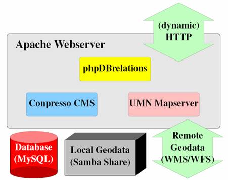
New database driven website approach (05/2006)Switching existing SFB 574 website to new database driven approach The previously existing SFB website (from phase I) has been transformed into a synoptic web portal (http://www.sfb574.uni-kiel.de). A metadata catalogue and a dynamic mapping solution have been added. Data are served from a central database, cross-links between different areas of the website are automatically created, a poster section, a search form and a site map have been implemented. Before the new web portal was implemented, the existing website was analyzed and compared to the website of the former SFB 267 "Deformation Processes in the Andes", a more advanced web/database system was developed. This system incorporates modern database technology and implements an integrated SFB 574 data catalogue that was prepared in cooperation with all subprojects (compare fig. 1).
Figure 1: Behind the scenes: Using the apache webserver and a MySQL database, we are using the "Conpresso Content Management System" (CMS) for static content. Dynamic content is managed using the phpDBrelations toolkit with its export routines for HTML and XML. For web mapping, the UMN Mapserver is used via the PHP/Mapscript framework. The first step in preparing the new web/database system was the transfer of personal data of SFB members, the structure of the SFB subprojects, cruise and expedition data, publications and presentations, together with the metadata associated with all existing SFB datasets, into a central database. An export system called phpDBrelations was developed. This system makes the export of specialized information from the database into relevant parts of the website a user-level task. We like to mention, that the used software is mostly not commercial. The "Conpresso Content Management System" (CMS) was improved by integrating "phpDBrelations", a system developed by our group. Essentially it is a web based tool for creating and modifying database tables and relations. Generalized export routines for web content have been programmed, for example, the queried content can be simply listed, sorted in tables or sent as XML. The data catalogue was implemented using a regional indexed structure on the user side. Links between different, but related thematic blocks of the website are automatically generated from the central database system and the internet user can browse this structure or use the search forms to find the desired datasets (see e.g. fig. 2). In addition to the SFB datasets, freely-available datasets from external sources (e.g. satellite imagery, global geopotential models and topographic and bathymetric databases) are integrated. Where possible, this external information is integrated using internet services like Web Mapping Service (WMS)/Web Feature Service (WFS), as it has been done for the SRTM30 plus datasets shown in figure 3. If no standard exchange services are provided, custom filters can be integrated into this system, as it has been done e.g. for the USGS Earthquake Hazards Program.
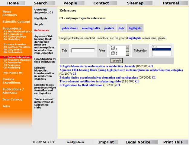
Figure 2: All specialized search forms query the same central database, carrying out more or less specific procedures, from simple text search in the highlights section (shown here) up to spatial queries on the metadata catalogue. Information from the data catalogue can be extracted and instantly presented in dynamically-created maps. This web-mapping solution is based on the UMN Mapserver (http://mapserver.gis.umn.edu/index.html) and the maps created rely on dynamic HTML. In addition, using the web-mapping interface, it is now possible to extract all data that are available for a particular area. To guarantee data security and minimize possible downtime of the SFB 574 website, database and storage, the facilities of the central computing department (Rechenzentrum) of the Christian-Albrechts-Universität (CAU) provides the infrastructure used for the web portal. Regular backups of storage and database systems ensure the reliability now and possibly the sustainability in the future, as the system is centralized and its maintenance is regular.
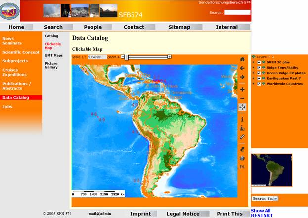
Figure 3: Map of central and South America showing both, the old and new SFB research area. SRTM30 plus dataset is included via Web Mapping Service (WMS), most recent earthquakes from the USGS Earthquake Hazards Program have been integrated using custom filters. |
Events
Kieler Wissenschaftler fühlen den 'Puls der Erde' Wie funktioniert die Recyclingmaschine der Erde?Nach elf Jahren endet der Kieler Sonderforschungsbereich 574 zu Subduktionszonen Final colloquium of SFB 574 Teilprojekt ÖffentlichkeitsarbeitMEERESFORSCHUNG FÜR MICH UND DICH |
|
©SFB574 // Wischhofstrasse 1-3 // D-24148 Kiel // T. +49 (0)431 600 1413 // elange [AT] geomar.de