")
")
")
 Web Content Anzeige Web Content Anzeige
Theme A: Subduction zone structure and tectonicThe theme A subprojects use geophysical imaging techniques to study major parts of the subduction system which includes the incoming plate, forearc, magmatic arc and toward the depth the mantle wedge. Major research topics are the structure and hydrogeology of the marine accretionary forearc, the study of earthquake processes and seismicity, zones of slab dehydration, serpentinization of the incoming plate and mantle wedge, regions of melt formation and lithospheric structure in a synoptic view. Main research goals of theme A include:
In the next working phase III, subprojects of theme A will focus their the research on the south-central Chilean subduction zone. There, they will apply to remote sensing techniques to define the geometry of the upper Andean crust and topography. Further aims are the investigation of the behavior of seismogenic coupling megathrust zones; the assess of volatile fluxes into the subduction zone which is related to lithospheric velocity and density distribution. Therefore fluid and magma pathways can be detected between the subducting slab trough the mantle wedge into the crust and arc. In addition to the study of volatile fluxes and structural features of the south-central Chilean subduction zone, theme A subprojects will also study hazards from slope instability in the marine forearc (A1) and seismic hazards caused by megathrust earthquakes (A2, A5, A6) and active volcanoes (A2). A1 will use multi-scale mapping tools to study potential sites of seawater percolation through the crust into the mantle of the incoming Nazca plate along bending-related normal faults. These faults may facilitate hydration of the downgoing plate prior to subduction. Hydration and hence serpentinization of the incoming plate is studied by A5, defining the amount of chemically-bound water carried with the downgoing plate into the south-central Chilean subduction zone. Constraints on volatile fluxes from A5 will be used and balanced against the output through the magmatic arc in the theme C subprojects, as has been done in Central America. In addition, A1 defines and investigates sites of seepage into the marine forearc where accretion of sediments and sediment diagenesis cause dewatering and fluid escape, providing critical information for the theme B subprojects in its role as "pathfinder". In 1960, a great earthquake of Mw=9.5 shook the entire Chilean margin to the south of Concepcion, resulting from the rupture of the plate interface between ~38°S to 45°S. A2 will focus on a interdisciplinary study of different geophysical methods: members of A2 will install a land-based seismological network covering the forearc and the arc between 39°S and 40°S, where the greatest slip occurred during the 1960 earthquake. The network will include the Villarrica Volcano, presently one of the most active volcano in South America. Gravity and magnetic fields data which are already exist in the area should completed in areas where the coverage of data is rare. Data and modeling will yield seismicity, slab geometry, forearc and arc structure, which will be used to constrain the relationship between the seismic coupling, volcanism and active upper plate fault systems. A2 will closely cooperate with theme C subprojects on the issue of seismic-volcanic hazards. On the other hand, A1 will attempt to detect possible relationships between earthquake activity and submarine landsliding caused by slope instability, especially in the longterm structural record. A seismic study will be carried out between 34°S and 36°S within A5 which will contribute to the problems defined in subproject A2. The northern seismic network contains on- and offshore stations and aims to investigate the relationship between hydration of the incoming plate in the trench-outer rise and the infiltration of water into the forearc mantle, causing serpentinization of the mantle wedge. Although the land-based components of both experiments are quite similar, the natural seismicity in both settings is very different. North of ~36°S, intermediate depth seismicity (70-~200 km) is abundant and earthquakes interpreted as interface events have been reported in global catalogues. The occurrence of intermediate depth earthquakes is essential for the goals of A5 as they will be utilized as sources for seismic tomography. However, to the south of ~39°S, where the great 1960 earthquake occurred, both interface and intermediate depth seismicity is sparse. A6 will integrate the structural data from A2, A5 and previous projects in Central Chile in a 3D GIS and combine thermal (Finite element) and 3D density and susceptibility modeling of the potential fields, constraining the structure and dynamics of the subduction zone system and the relationship between incoming plate and upper plate features. Curie temperatures will be calculated by a combination of fractal and Fourier space domain calculations. Thermal constraints will help to differentiate between seismicity patterns in the northern and southern study areas. Since the occurrence of intermediate depth earthquakes it is believed that earthquakes are related to dehydration processes and depend on temperature and pressure conditions, thermal constraints can be used to study factors controlling volatile fluxes from the subducting lithosphere into the mantle wedge and its along arc variability. Detailed thermal modeling carried out within A6 will nurture modeling efforts of the C projects, refining geochemical fluxes and the subduction water cycle.
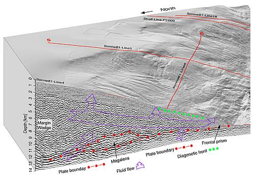
Figure A-1: The deep-sea trench, a highly complex continental margin, and the relief of the oceanic plate are the major morphologic and tectonic elements of a subduction zone. Off Costa Rica the division and complex structure of the wedge and slope result from slumping, seamount subduction, sediment influx from the fore-arc, and accretion of sediments riding on the oceanic crust. The seismogenic zone (red dots), dewatering along bedding planes or other zones of high permeability (blue), and the diagenetic front green) are the main transport loops for volatile return and reactions to build reservoirs. The seismic Line 4 is 58 km long from the toe to the upper continental slope. The top of the margin wedge is smooth beneath the upper slope, cut by small throw normal faults (inset e). Fault throw grows and fault dip decreases downslope and the top of the margin wedge becomes rougher. The canyons in the upper and middle slope indicate a relatively stable environment where no seamount has recently underthrusted. Thrust faulting occurs only at the small frontal prism. The frontal prism is a distinct morphological unit, tectonically active as indicated by the disruption of the slope drainage system and most probably the site of dewatering through cold seeps. The plate-boundary reflections at he decollement bifurcate at ~ 6 km depth and delineate one of several rock megalenses (Ranero and von Huene, 2000). |
Events
Kieler Wissenschaftler fühlen den 'Puls der Erde' Wie funktioniert die Recyclingmaschine der Erde?Nach elf Jahren endet der Kieler Sonderforschungsbereich 574 zu Subduktionszonen Final colloquium of SFB 574 Teilprojekt ÖffentlichkeitsarbeitMEERESFORSCHUNG FÜR MICH UND DICH |
|

©SFB574 // Wischhofstrasse 1-3 // D-24148 Kiel // T. +49 (0)431 600 1413 // elange [AT] geomar.de