")
")
")
 Web Content Display Web Content Display
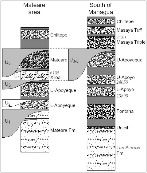
Stratigraphy and EruptionparameterComplete stratigraphic successions were established in central western Nicaragua, however, including Apoyo, Masaya and Chiltepe volcanic complexes. Our composite stratigraphy (Fig. 1) is a major improvement over earlier results by Bice (1985) in that it provides a complete record of highly explosive eruptions for the younger part of the sequence and recognizes different older successions north and south of Managua. The stratigraphy of the older sequences will be detailed by ongoing field work. Field stratigraphic correlations are based on modal composition and texture of pumice, structures of the deposit, relative sequence, unconformities and the nature of intercalated sediments. They are supported by characteristic chemical compositions and by physical dating.
Fig. 1: Comparison of composite stratigraphic logs of products of highly explosive eruptions in west-central Nicaragua from Bice (1985) and our work. Black= mafic tephra, white= silicic tephra, gray= intercalated sediment and soil, vertical hatching= older formations, stratigraphic work in progress. Silicic tephras from Lower Apoyeque through Chiltepe Pumice erupted from the Chiltepe Volcanic Complex, Lower and Upper Apoyo tephras erupted from Apoyo Caldera, the three basaltic tephras originate from Masaya Caldera, the source vent location of the Unicit Pumice is unknown. Mateare Formation is exposed north of Mateare, Las Sierras Formation south of Managua. Radiocarbon DatingWe obtained six new radiocarbon dates on charcoal, soil, and fossil plant material from several tephra layers. Absolute dating is essential in our work to determine temporal changes but well datable material proved difficult to find. These dates support our relative stratigraphy and especially our revision of the relative timing of the Xiloa Tephra and Masaya Triple Layer eruptions. They also support our field-based conclusion that there was only a very short time interval between the Lower and Upper Apoyo eruptions. Unfortunately we could not yet obtain reliable dates for the lower end of our correlated sequence, i.e. the Fontana or Unicit eruptions.
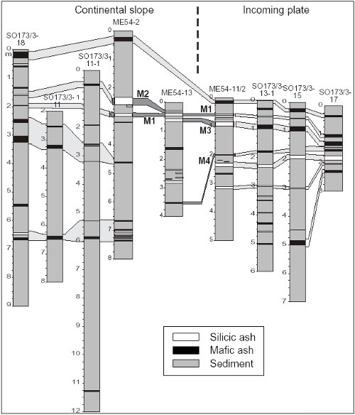
Fig. 2: Major regional unconformities in the stratigraphic successions of the Mateare area along the west bank of Lago de Managua, and the area from Managua south to Masaya. The hilly country south of Managua formed mainly during Las-Sierras times but was reinforced by an erosive phase prior to the Masaya Triple Layer eruption. Unconformities U0-U5 discussed in the text. Unconformities and climateThe younger tephra sequence above the Las Sierras Formation south of Managua is basically conformable except for rare small, flat, local erosional channels. One major erosional unconformity with amplitudes exceeding 15 m (the exposed maximum) occurs at the base of the Masaya Triple Layer reflecting major erosion between 2,000 and 6,000 years BP. The younger tephra sequence above the Older Mateare Formation along the west coast of Lago de Managua, however, is characterized by several major erosional unconformities. The first major (>30 m exposed amplitude) unconformity (U1 in Fig. 2) truncates the Mateare Formation and is overlain by the Lower Apoyeque Pumice. The water level of Lago de Managua 6000 years ago was c. 9 m higher than today as evidenced by fine-grained lake sediments overlying Lower Apoyeque Pumice (U2) at Mateare and fossil shore lines exposed near Managua (Cowan et al. 2002). Since then, the lake level dropped at an average rate of c. -1.5 m per 1000 a. Local erosional channels (U3) between Upper Apoyeque Pumice and Xiloa Tephra are filled with immature fluviatile sands. Unconformity U4 between Xiloa Tephra and Mateare Pumice is covered by beach and tsunami sands as described below. A high amplitude unconformity (U5) occurs on top of the Mateare Pumice, filled with 10-m-thick channel fills of fluviatile sands and flash-flood deposits. The time interval from Lower Apoyeque to Mateare eruptions was thus characterized by intense water shedding and erosion associated with high lake level, suggesting a period of a few thousand years characterized by repeated unusually high rain falls. The last such period (U3-U5) in the Mateare area corresponds in time with the major erosive phase immediately prior to emplacement of the Masaya Triple Layer in the southern Managua area. The change to present-day relatively dry climate conditions took place prior to eruption of the Chiltepe Pumice. Interestingly, the period of increased precipitation and erosion corresponds to a high average frequency of highly explosive eruption about 1/1000 years compared to only <1/5000 years during earlier, less erosive periods. This suggests a correlation between climate and volcanic activity, a subject that will be studied more closely during Phase II.
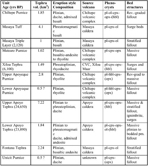
Fig. 3: Core logs from METEOR M54 and SONNE SO173 cruises off-shore Nicaragua showing distribution of ash layers. M1 to M4 are ash layers in M54 cores which we correlated using geochemical analyses. Light gray connectors indicate tentative correlations among other cores based on hand-specimen observations that will be substantiated by ongoing analyses. Marine TephrostratigraphyAsh layers recovered in 3 cores taken off-shore Nicaragua during RV METEOR cruise M54 in 2002 were analyzed while study of abundant ash layers in 8 cores recovered during RV SONNE cruise SO173 in 2003 is underway. The METEOR cores contain 6 basaltic and 14 silicic ash layers (0.5 to 14 cm), as well as abundant dispersed ash. The felsic ash layers represent highsilica K-rich rhyolite, low-K rhyolite, and dacite (555 EMP analyses). Glass and mineral compositions allowed to correlate ash layers with deposits on land and, in part, between cores, (M1 through M4 in Fig. 3), only M1 being present in all 3 cores. Ash layer M2 represents the distal Upper Apoyeque pumice while ash layer M3 corresponds to the Upper Apoyo Tephra. Basaltic ash layer M4 is tentatively correlated with the Fontana Tephra, depending on trace element concentrations because major-element compositions of the mafic tephra largely overlap. Ash layer M1 compositionally matches the 2,720 years old Ometepe Pumice we have sampled at Concepción volcano but must be older since it is bracketed by Upper Apoyeque and Upper Apoyo deposits. It probably represents an older eruption from the Ometepe Volcanic Complex which we will study in more detail during Phase II. Description of eruptions and their productsThe younger tephra succession The following table summarizes essential features of the tephra units from top to bottom of the succession for brevity. Other observed characteristics such as color, pumice vesicle texture, and types and contents of lithics have also been used to establish correlations between outcrops and to infer eruptive processes.
The older Formations The Mateare Formation is a mostly conformably stratified sequence (>100 m thickness exposed) of pyroclastic and epiclastic deposits in the area north of the town of Mateare. It is capped by a deep relief-forming unconformity overlain by the Lower Apoyeque Pumice. The Mateare Formation comprises numerous basaltic, dacitic and strongly compositionally zoned tephras and is thus compositionally distinct from the previously described basaltic Las Sierras Formation. The Mateare Formation may represent earlier phases of the Chiltepe Volcanic Complex but this is subject of our ongoing work. The Las Sierras Formation is a sequence of epiclastic deposits and basaltic fallout and surge beds underlying the Unicit Pumice. There is no apparent depositional break so that the definition of the Las Sierras top boundary is rather arbitrary. Most of the pyroclastic deposits appear to represent a pre-caldera huge Masaya volcano and its subsidiary vents. Eruption parametersWe have constrained physical parameters of each individual eruption based on detailed isopach and isopleth mapping in 2002 and 2003, covering an area of 4500 km2, encompassing c. 170 locations. These data allowed to calculate total volumes and masses of the erupted material, eruption column heights, magma discharge rates, and minimum eruption durations. Total tephra volume was obtained by constructing straight-line segments on plots of ln(isopach thickness) versus square-root(isopach area) following Fierstein and Nathenson (1992). Tephra volumes were converted to erupted magma masses assuming an average 60 vol% of pores and lithics and 2300 and 2600 kg/m3 density for felsic and mafic compositions. Cross-range widths of MP- and ML-isopleths, where MP and ML are average diameters of the five largest pumice and lithic clasts at an outcrop, were compared with eruption-column modeling results of Carey and Sparks (1986), Wilson and Walker (1987), Woods (1988) and Sparks et al. (1992) to estimate eruption column heights and magma discharge rates. Isopach constructions emphasize the importance of marine ash layer data to arrive at realistic eruption parameters as a prerequisite to quantify volatile fluxes from highly explosive eruptions. |
Events
Kieler Wissenschaftler fühlen den 'Puls der Erde' Wie funktioniert die Recyclingmaschine der Erde?Nach elf Jahren endet der Kieler Sonderforschungsbereich 574 zu Subduktionszonen Final colloquium of SFB 574 Teilprojekt ÖffentlichkeitsarbeitMEERESFORSCHUNG FÜR MICH UND DICH |
|


©SFB574 // Wischhofstrasse 1-3 // D-24148 Kiel // T. +49 (0)431 600 1413 // elange [AT] geomar.de