")
")
")
 Web Content Display Web Content Display
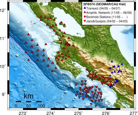
Overview Theme A2The convergent margins of Nicaragua and Costa Rica show strong variability in the structure of the incoming oceanic plate, the activity of the seismogenic zone, dip and depth extent of the Wadati-Benioff-Zone, and in the chemical signature and geographic alignment of arc volcanism. These variations are thought to be indicative of coupled subduction processes involving stress-transfer, mechanical and metamorphic fluid release and (partial) melting. During SFB phase I dynamic models of mantle flow and fluid release have been developed (SP C1, C5) describing the role of sediments, oceanic crust and serpentinized mantle as a slab-fluid source in a subduction scenario. One of the major goals of subproject A2 in phase II has been to establish the structural and dynamical framework for generic subduction process modelling on the basis of seismological investigation. Local earthquake tomography of several networks and a receiver function study provide insight into the subduction zone resolving slab geometry, Moho depth, velocity pertubations and Vp-Vs-ratio. The latter can be related to fluid content. Non-volcanic tremors recorded on borehole stations on Nicoya Peninsula are thought to be related to fluid processes but are not yet fully understood as to their mechanism.
Fig. 1: Seismological Networks in Nicaragua and Costa Rica: red inverted triangles - short period stations; blue triangles - broad-band stations.
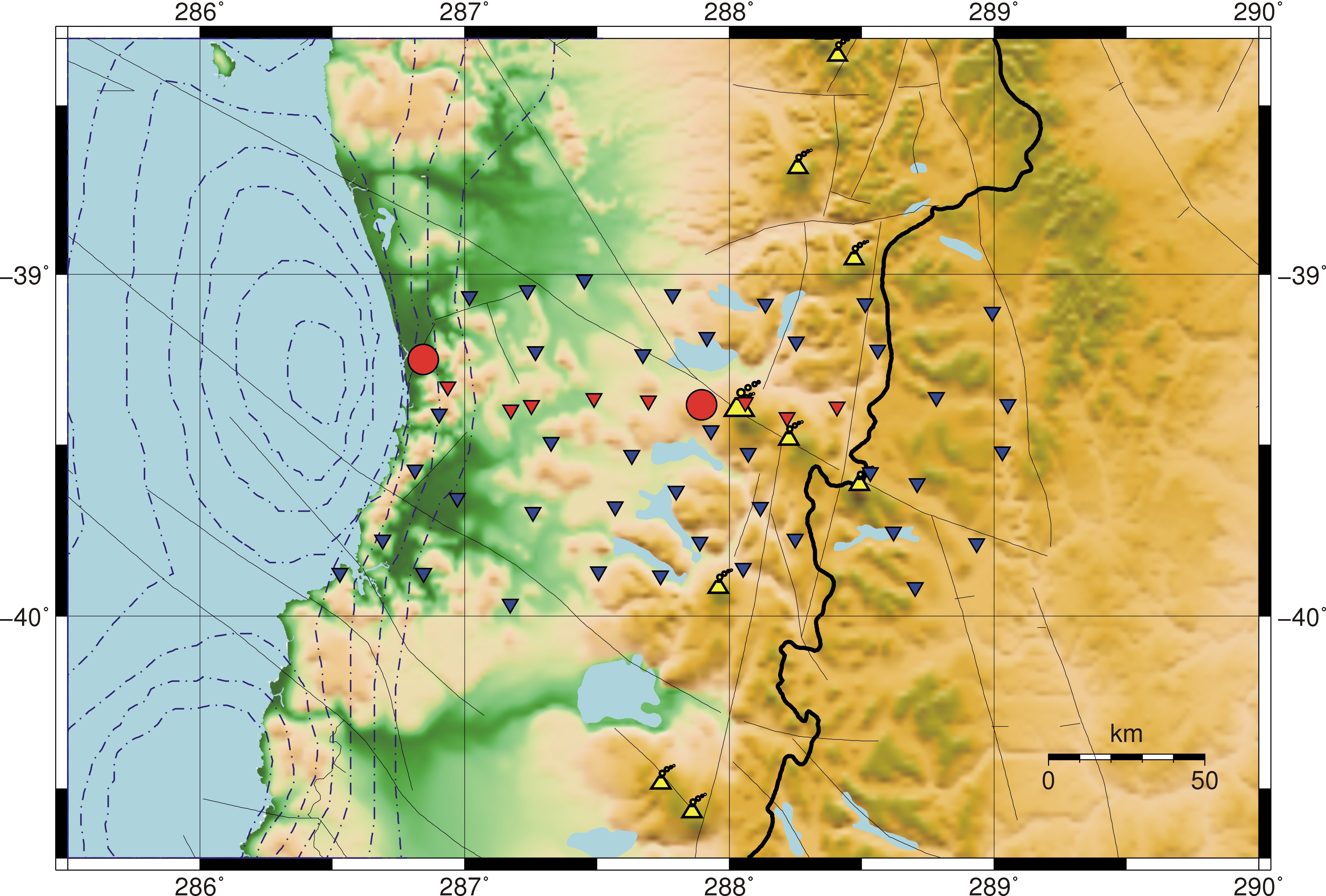
After investigating the transitional setting of the Central American subduction zone in phase III, the focus of the investigations in phase III has moved to South America, which is a continental end-member of subduction zones. Seismicity and volcanism in Chile and Argentina are influenced strongly by sediment input into the trench, oblique convergence and resulting strain partitioning, and pre-Andean characteristics of the overriding plate. Furthermore, the occurrence of the largest instrumentally recorded earthquake, the 1960 Mw 9.5 Valdivia earthquake, close to the very active Villarrica Volcano, makes this region ideally suited for subduction-related hazard investigations. The geometry of the subduction system (slab dip, crustal thickness) is well constrained north of 39°S, but not further south where the 1960 coseismic slip was largest. A seismological network has been installed in the Villarrica area in autumn 2008 for one year, with the following aims:
Fig 2: Seismological network in Chile - Villarrica region: blue inverted triangles - short-period stations; red inverted triangles - broad-band stations; red circles - clusters of 3-4 broad-band stations. Dashed-dotted lines give the slip contours of the 1960 Valdivia earthquakes, yellow symbols denote the principal volcanoes. Contact: Yvonne Dzierma |
Events
Kieler Wissenschaftler fühlen den 'Puls der Erde' Wie funktioniert die Recyclingmaschine der Erde?Nach elf Jahren endet der Kieler Sonderforschungsbereich 574 zu Subduktionszonen Final colloquium of SFB 574 Teilprojekt ÖffentlichkeitsarbeitMEERESFORSCHUNG FÜR MICH UND DICH |
|
©SFB574 // Wischhofstrasse 1-3 // D-24148 Kiel // T. +49 (0)431 600 1413 // elange [AT] geomar.de